


Get The Latest News!
Don't miss our top stories and need-to-know news everyday in your inbox.
ALTON – Last weekend's tremendous wind event came rather unexpectedly for both citizens and the meteorologists at the National Weather Service (NWS).
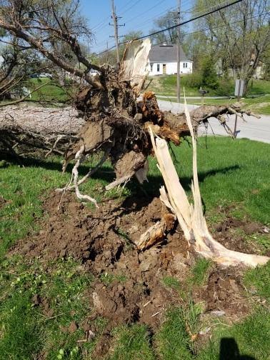
The winds, which gusted from 45-60 mph came as a small-but-powerful low pressure system in the wake of rainfall earlier that night. NWS Meteorologist Jon Carney said the difference in the gradient between the high and low pressure in the area in the predawn hours of Sunday morning caused the winds to gust at the speeds they did. Those gusts, according to St. Louis media, were strong enough to blow the iconic Grove sign in St. Louis into the street. They were also strong enough to blow the pine tree in Jade Duhamell's backyard into the fence between her home and her neighbor's.
“There were a bunch of moles in the yard, so the ground was soft, that may have helped the tree come up,” she said. “I heard a thump and wondered, 'what the hell was that?'”
That thump was the pine tree shading her bedroom and kitchen during the hot summer months slamming to the ground. If it were taller, Duhamell said it may have damaged her neighbor's property.
“When we first moved here two years ago, I thought about cutting it down,” she said. “Its needles would get everywhere and hurt my feet, and we'd track it into the house. But it gave good shade for the kitchen and bedroom in the summer.”
Duhamell said she loves storms and rain, but said the storm this past weekend was among the worst wind events she had ever experienced – even considering her time living on an island off the coast of Florida.
Carney said the event is actually decently rare. When gust fronts like the one experienced across the area early Sunday morning do occur, they usually follow a well-formed line of severe thunderstorms – often referred to as a “squall line.” Carney said no lightning was detected at the St. Louis office of the NWS during the weather event.
“We often don't know something like this is going to happen until it starts happening,” he said. “We knew it was going to be breezy, but we were not expecting 60 mph gusts like we had.”
Many people reported to have lost power during the storm on social media. A look at Ameren Illinois's outage map showed fewer than 50 people without power in the area around noon, and that number has dropped from around 48 to around 36, according to that map, as this story is being written. A representative from Ameren Illinois is sending Riverbender.com a comprehensive release detailing the extent of the outages immediately following the storm, which will be published as an update later today.
The Riverbend experienced rain with that system, but areas just north and west received snow. Carney said a band of snow reached from Columbia to Hannibal in Missouri. Most of the locations impacted by that last gasp (hopefully) of too-long of a winter experienced a half of an inch to two inches of snow, but a trained weather spotter in Hannibal reported as much as three-and-a-half inches of snow had fallen there.
For the rest of the week, Riverbend residents can expect another round of precipitation coming later in the week. Carney said thunderstorms are likely both Wednesday night and Thursday afternoon. As of now, only the Thursday storms bring a chance of severe weather, which at this time could mean more strong winds accompanied by hail.
Following that precipitation will be cooler temperatures – for at least a day. Friday may struggle to break 50 degrees, but Carney said Saturday will reach the mid-to-upper 60s and Sunday will again break 70.
“It's April, we have a pretty strong sun angle following the spring equinox, heading into summer,” Carney said. “It's going to be pretty good daytime heating.”
As for flood forecasts, Carney said the large rivers such as the Mississippi, Missouri and Illinois are not as affected by local rains as they are rains and snow melts from the Northern Mississippi River Basin. He said there are no large effects on flooding predicted at this time, but the NWS in St. Louis updates its 28-day flood forecast every Wednesday.
More like this: