Flood levels for Alton, Grafton, Hardin and St. Louis

Levels at Alton IL


Flood Categories

Primary (ft)

  • Action : 19 ft
  • Minor : 21 ft
  • Moderate : 29 ft
  • Major : 34 ft

Flow (secondary) data is not currently enabled for this gauge.

Gauge Data

Forecast Issued: Apr 17, 2024 08:24 PM -0500

Recent

Recent Category: Normal
Recent Projected Forecast Available: 9.2 ft
Recent Projected Forecast Time: Apr 18, 2024 01:00 PM -0500

Highest

Highest Category: Normal
Highest Projected Forecast Available: 10.6 ft
Highest Projected Forecast Time: Apr 22, 2024 07:00 PM -0500

Last

Last Category: Normal
Last Projected Forecast Available: 10.2 ft
Last Projected Forecast Time: Apr 27, 2024 07:00 AM -0500


U.S. Geological Survey (USGS) Data and Site Info for Mel Price (Alton) Lock and Dam: USGS ID: 05587541

Levels at Grafton IL


Flood Categories

Primary (ft)

  • Action : 18 ft
  • Minor : 20 ft
  • Moderate : 24 ft
  • Major : 29 ft

Flow (secondary) data is not currently enabled for this gauge.

Gauge Data

Forecast Issued: Apr 17, 2024 08:24 PM -0500

Recent

Recent Category: Normal
Recent Projected Forecast Available: 15.4 ft
Recent Projected Forecast Time: Apr 18, 2024 01:00 PM -0500

Highest

Highest Category: Normal
Highest Projected Forecast Available: 15.6 ft
Highest Projected Forecast Time: Apr 22, 2024 01:00 AM -0500

Last

Last Category: Normal
Last Projected Forecast Available: 15.5 ft
Last Projected Forecast Time: Apr 27, 2024 07:00 AM -0500


U.S. Geological Survey (USGS) Data and Site Info for Grafton: USGS ID: 05587450

Levels at Hardin IL


Flood Categories

Primary (ft)

  • Action : 24 ft
  • Minor : 25 ft
  • Moderate : 31 ft
  • Major : 32 ft

Flow (secondary) data is not currently enabled for this gauge.

Gauge Data

Forecast Issued: Apr 17, 2024 08:24 PM -0500

Recent

Recent Category: Normal
Recent Projected Forecast Available: 22.9 ft
Recent Projected Forecast Time: Apr 18, 2024 01:00 PM -0500

Highest

Highest Category: Normal
Highest Projected Forecast Available: 22.9 ft
Highest Projected Forecast Time: Apr 19, 2024 07:00 AM -0500

Last

Last Category: Normal
Last Projected Forecast Available: 22.8 ft
Last Projected Forecast Time: Apr 24, 2024 07:00 PM -0500


U.S. Geological Survey (USGS) Data and Site Info for Hardin: USGS ID: 05587060

Levels at St Louis MO


Flood Categories

Primary (ft)

  • Action : 28 ft
  • Minor : 30 ft
  • Moderate : 35 ft
  • Major : 40 ft

Secondary (kcfs)

  • Action : Not Set
  • Minor : Not Set
  • Moderate : Not Set
  • Major : Not Set

Gauge Data

Forecast Issued: Apr 17, 2024 08:24 PM -0500

Recent

Recent Category: Normal
Recent Projected Forecast Available: 10.3 ft
Recent Projected Forecast Available (Secondary): 198 kcfs
Recent Projected Forecast Time: Apr 18, 2024 01:00 PM -0500

Highest

Highest Category: Normal
Highest Projected Forecast Available: 11.7 ft
Highest Projected Forecast Available (Secondary): 214 kcfs
Highest Projected Forecast Time: Apr 26, 2024 07:00 PM -0500

Last

Last Category: Normal
Last Projected Forecast Available: 11.6 ft
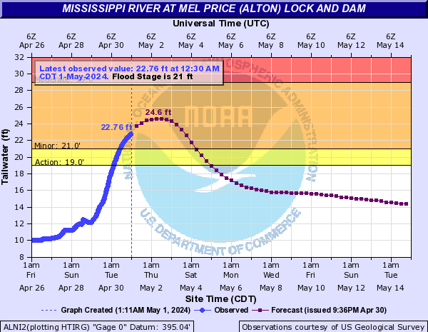
Last Projected Forecast Available (Secondary): 213 kcfs
Last Projected Forecast Time: Apr 27, 2024 07:00 AM -0500


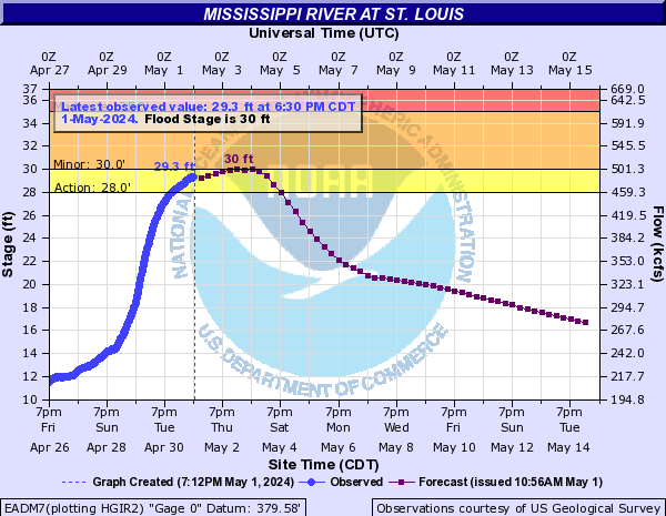
U.S. Geological Survey (USGS) Data and Site Info for St. Louis: USGS ID: 07010000
Join our mailing list Subscribe to our Daily Update
Contact
200 W. Third Street | Alton, IL 62002
Suite 200
618.465.9850
HOME  |   Advertise With Us  |   Job Opportunities  |   Our Partners  |   Web Design Services  |   Contact US  |   Site Map   |  RSS Feeds  |  Email   |  Privacy Policy